story in a nutshell
the finnish municipal octapoint shown by the zoomable official map in the following link
http://tinyurl.com/5ws4qu& monumented by the rock & iron boundary pins pictured here

will be reduced to a septipoint next year
when its 2 largest slices of territory are merged into a single commune
in keeping with the recent national policy of consolidating local governments
& this will leave unrivaled as the most complex multipoint in the world the philippine octamunicipal point schematically depicted here

but in fact demarcated only by the summit point
or more likely an open vent hole
on the nearly perfect conical volcano shown here
http://tinyurl.com/6hflnbbut there is a bit more to this strange story
while tripoints are the most obvious & common try points of trypointing art & sport & ritual
& while the 176 worldclass tripoints or 3country conjunctions such as atczsk & czplsk etc are clearly preeminent
nevertheless all multipoints may be equally fair game as try points
& indeed the multipoints subsume not only all the myriads of subdivisional tripoints
such as the tristate points & tricounty points & trimunicipal points etc
but they also include on most if not all subdivisional levels a small handful of megapoints
so to say
which comprise all the multipoints of more than 3 boundary components or geopolitical constituents
such as the quadripoints & quintipoints & so on
up to the octapoints
so far as is thought to exist anywhere on earth at this time
there is even
at the south pole of all places
or rather there arguably was until 1959 but is now legally suspended
or frozen as it were
a 6country 11boundary multipoint
which might be called a sexinational hendecapoint
as shown below
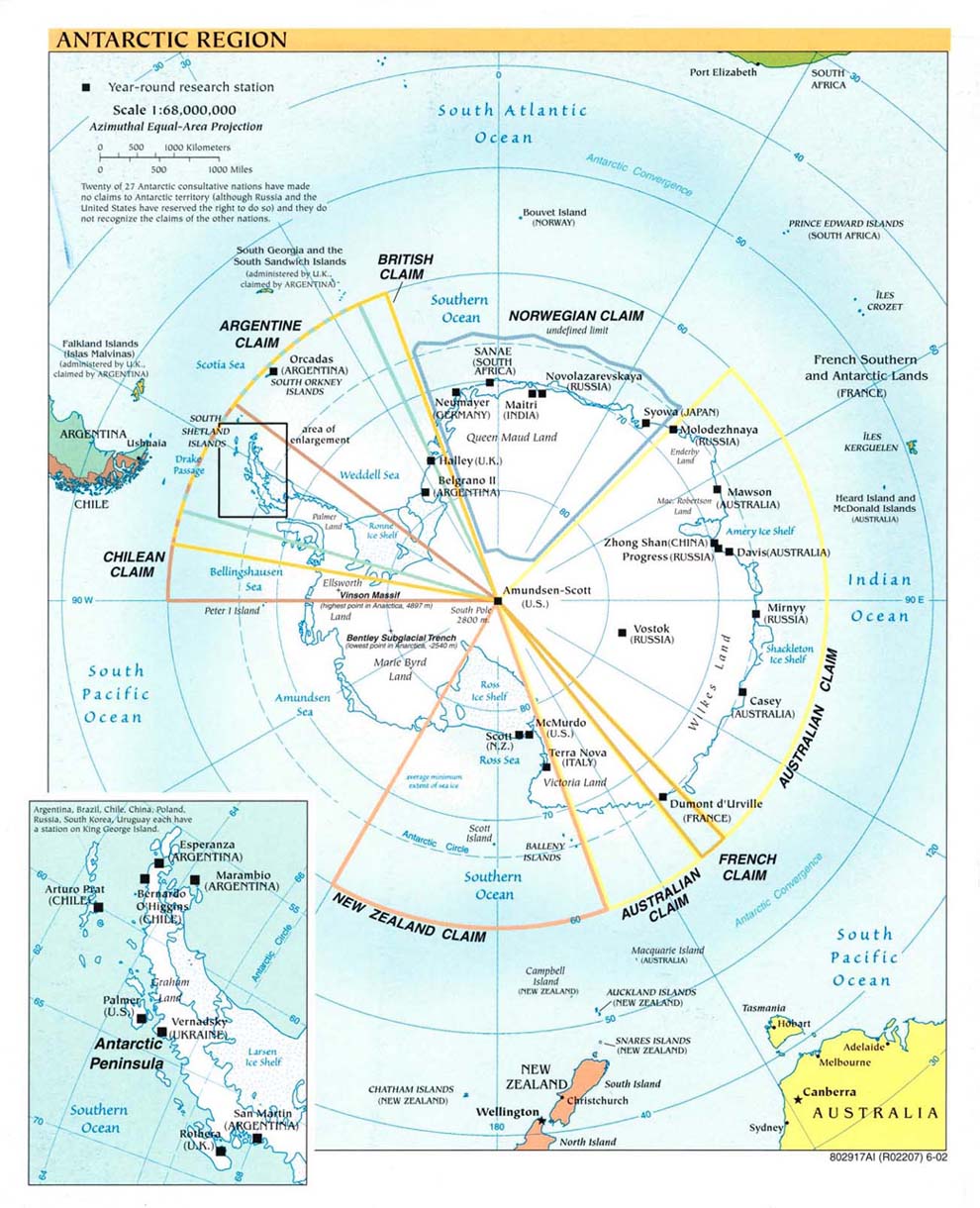
& this extreme megapoint was until its discontinuance & would still have been today the undisputed global maxipoint
with no serious competition anywhere in sight
but in fact the very quest to recognize & reach the true & present global maxipoint has constituted a trypointing try in its own right
involving a multitude of factors
for if there had been in existence any worldclass megapoint at all
which is to say
any multicountry conjunction more complicated than an ordinary trijunction
it is unlikely that the global maxipoint quest would have progressed any farther than that point
as recently as the 1990s boundary scholars could not rule out the possibility of a quadricountry point existing at the terrritorial convergence of botswana namibia zambia & zimbabwe
in the confluence of the chobe & zambezi rivers
not far above victoria falls
& this was the great bwnazmzw hopeful
so called
holding out against all probability in face of both poor mapping & international disputes
until satpic images revealed it was really not a quadripoint at all
but rather a distinct bwnazm tripoint & a distinct bwzmzw tripoint
both afloat within the river confluence area all right
yet still about 350 meters apart
so this leading candidate to succeed the south pole as global maxipoint has bitten the dust
& has had to be content of late as just a very distinguished & very close couple of members
of the worldclass set of 176 coequal tricountry conjunctions
& with the primary level of multipoints thus positively confirmed to comprise only tripoints & to be in fact devoid of any megapoints
the quest for global maxipoint then necessarily fell back upon the megapoints of the secondary level
& here there is no great scarcity
for subdivisional quadripoints like the famous azconmut or indian 4corners of the southwestern united states are confirmed or very probable in quite a few countries
such as andorra argentina bulgaria canada the dominican republic gabon india jamaica liechtenstein libya mauritania oman the philippines st kitts & nevis sudan uganda vietnam etc
indeed a subdivisional quadripoint & even a quintipoint exist among the parishes of st kitts & nevis respectively as numbered below at 2 6 9 13 & 4 5 7 10 12
tho these were only recently revived politically after languishing in obscurity for a time as purely ecclesiastical relics

&
for lack of any clear predominance within the primary level
owing to the general numerical similarity of all the 176 worldclass multiconjunctions
& for lack also of any clear predominance among the many second order quadripoints in the world
the recently revived nevis quintipoint
being technically the grandest second level multipoint in the world
may serve today by default as the most eminently complicated of the major multipoints
& thus as a sort of global maxipoint
tho not a very good exemplar really
since a secondary quintipoint represents neither the highest available political level nor the highest available numerical level
but would be at best a result & expression of compromise & inexact thinking
& thus not a very successful outcome of an earnest & multipunctilious trypointing try
moreover it may well be fairer to say that the florida quinticounty point in lake okeechobee
tho technically of only the tertiary level
is geopolitically far more important than the secondary level quintipoint of st kitts nevis
in terms of its constituent population data & the actual political clout of the entities involved
inasmuch as the least of the 5 okeechobee counties is more populous than the entire island of nevis
& the full population of all the 5 okeechobee counties is 135 times greater than all nevis
while a comparison of the total geographical areas covered is more overwhelming still
but in any case
in the belief that the okeechobee quintipoint was the global maxipoint at the time
a demarcation expedition was undertaken in 2001
from which the following pix are outtakes
http://tinyurl.com/6p7eho
http://tinyurl.com/6zzmsy
an account of the try is given here
http://groups.yahoo.com/group/BoundaryPoint/message/1391
but all this was actually a bit naive
for upon further revelation & reflection as well as the passage of time
it now seems the maxipoint quest has no choice but to settle exclusively upon the greatest known number of component entities
& to disregard their political levels entirely
since the seemingly objective subdivisional ordering of primary secondary tertiary etc is as often a matter of local idiosyncrasy or happenchance as it is a reasonable measure of comparability
so the question has become
& will remain til a worldclass quadripoint should emerge to trump it
where is the numerically greatest multipoint in the world
without regard to geopolitical level
&
tho a few more quintipoints were subsequently found on various levels
several years then passed by without any clear determination of what might trump what
in point of preeminence
before the staggering finnish octapoint was discovered
& a few more years until the no less staggering philippine octapoint also turned up to join it in a tie for first place
in company with a similarly unique tho slightly less remarkable philippine sexipoint
to claim third place all by itself
& simultaneously with these 2 clear medalists
a supporting crowd of equally unexpected philippine quintipoints too
& so for a while the 2 octapoints have reigned as dual or twin global maxipoints
since the question of supremacy couldnt reasonably be called in favor of either one
the best sources make them both out as quaternary level entities
& both are technically octamunicipal too
& their exact ages are still unknown
so they have made a fairly good pair until now
indeed it seems ironic if not an outright cosmic joke that the great quest for a single global maxipoint will have finally been fulfilled
not by a more effective search or try but simply by the ongoing process of political development
yet it feels quite appropriate & satisfying to find that the new global maxipoint designate is in such a dramatic situation atop the spectacularly beautiful & highly active mayon volcano
even as the mountain itself has been deservedly nominated to become one of the new 7 wonders of the world in the following entertaining presentation
http://tinyurl.com/6dkjgjbest known pic

from
http://www.panoramio.com/photo/3962170
& finally it is also gratifying to find that all the numerical classes 3 thru 8 of the multipoints
from the almost ubiquitous tripoints & the modest scattering of quadripoints to the preciously rare quintipoints & the individually unique sexipoint septipoint & octapoint inclusive
will soon be represented for the first time in every category by a real example or examples


