Friday, June 19, 2009

a singular world maxipoint apparent

friends a really prodigious global boundary portent appears to be emerging this year

for on new years day
a municipal octapoint in finland that had long been considered the most multiple boundary conjunction in the world
was reduced to a septipoint
by a consolidation of local governments 

& this quiet event left the only other known octapoint on earth
which is in the cone of a philippine volcano called mayon
the last octapoint standing


&
since no more numerous a convergence of settled boundaries is believed to exist anywhere on earth
this marvelous philippine hot spot & vertex point 
held in common by 8 municipalities 
has thus become the one & only global maxipoint 
apparent

moreover
tho it is quite rare for any multipoint to incandesce & smoke or flame
nevertheless just this spring
as if performing on cue
a veritable honor guard of fellow volcanic multipoints around the world appears to be celebrating the ascendancy of mount mayon & of volcanic multipoints generally 
with some rather impressive displays of their own

first came volcan llaima in chile
at a relatively distinguished because interprovincial municipal tripoint
beginning in early april


& then a couple of weeks later 
gunung slamet in central java
evidently situated at no less than a quintipoint of regencies
joined in 
with an exceedingly unusual superpoint eruption
spewing extravagantly from the summit crater & dozens of surrounding cindercones 
& spraying lava up to 700 meters in the air dozens of times a day 
til this week

& most recently
seeming to emphasize both the multiplicity & universality of the party
there has also come a series of at least 3 eruptions of volcan galeras in colombia
the summit of which marks an otherwise ordinary generic trimunicipal point


& 
it is still fairly early in the year

& new volcanos pipe up somewhere on earth every 6 or 7 days on average

so there are still quite a few more chances for other multipoints to join the improbable pyrotechnic concert 
before this transitional year of 2009 is entirely history

even mount mayon itself 
tho it hasnt puffed since last august
has remained on standby alert all year

so we probably still have its inaugural spectacle to look forward to as well


as for what it may all mean
that an unmarked upstart of a multipoint in the wilds of the emerging world & very far east
tho practically unnoticed in the west as recently as 3 years ago 
has now fully supplanted a perennial favorite & well marked fixture of supercivilized europe
to the accompaniment of a great planetary flourish & fanfare
i will let you guess & the future reveal 
for yourselves  

but whatever the transition & demonstration may actually prefigure or presage or initiate
& wherever it may ultimately lead
it certainly has been a wonderment so far
to see this year of the volcanic maxipoint arising
& unfolding 
& now approaching its zenith

yours 
& keeping an eye out
a

Saturday, December 6, 2008

njnypa breakthru

folks i do believe all possibility of a dry njnypa tripoint has finally been extinguished

& i think i can now explain all the crazy monumentation of it
http://www.bjbsoftware.com/corners/photos/NJNYPATristateRockCloseup.jpg

http://www.bjbsoftware.com/corners/photos/NJNYPABoundaryMonumentNJ.jpg
etc

for i have just seen the only known congressional act that could have moved njnypa from the middle of the delaware river to the monumented point on the left bank at port jervis

& there doesnt seem to be any possible reading of it that would cause any displacement of the sovereign territorial tristate point whatsoever

at the same time it also becomes clear from a close reading of the act that the source of the confusion that supposedly but erroneously brought pennsylvania territory visibly to the left bank
is simply the existence of concurrent legal jurisdictions
of pennsylvania with both new jersey & new york
over the full river bed wherever their respective state lines follow the river midline

the njpa legal condominium actually predates the 1882 njny demarcation by 111 years

& the nypa jurisdictional condo was created in 1886 & ratified or reaffirmed by the act of 1890

so what we actually have today at port jervis are simply abutting 1771 njpa & 1886 nypa administrative condominiums
without any actual state territorial overlaps
nor any actual territorial or state line changes
nor any noticeable tripoint displacement
from colonial times up to the present hour

& while it is true that there is a jurisdictional triline
running across the full bed from bank to bank
between the abutting njpa & nypa areas of concurrent jurisdiction
still there is only a single wet territorial tripoint in the middle of that triline

for the njpa & nypa state lines are indeed still lines
or a single continuous line really
running along the exact middle of the delaware river
& conjoined precisely where the oblique njny state line proceeding w29n from the middle of the hudson river finally reaches the middle of the delaware river too

the 1890 congressional act ratifying the nypa demarcation of the 1880s that supposedly moved the njnypa tripoint from its original position in the middle of the delaware river to the purportedly demarcated terminal position at the 1882 tristates monument on the left bank does not in fact stipulate to any boundary changes

rather what it says is
the channel of the delaware river
from a line drawn across said channel
from a granite monument erected upon the eastern bank of said river in 1882 by the njny boundary commission to mark the western extremity of the njny boundary
in a westerly prolongation of said boundary line
up & along said channel of said delaware river as it winds & turns for about 85 miles
to a line drawn east across said river from a granite monument erected on the west bank of said river in 1884 etc etc
shall continue to be a part of the boundary or partition line between the said 2 states
provided however that the limit of territory between the said 2 states shall be the center of the said main channel
& provided further that each state shall enjoy & exercise a concurrent jurisdiction within & upon the water of said main channel between the lines of low water at either bank thereof between the limits hereinbefore mentioned

& i suppose it still remains to review the 1883 interim report & 1884 final report of the ny component of the 1882 njny boundary commission
for any definitive survey details & or true metes & bounds
so as to fully appreciate & rationalize the monumental mess at port jervis

but this njny boundary commission likewise changed no boundaries
nor had power to change any
nor are there any other known or supposed congressional ratifications of changes they couldnt possibly have made either

so

any further elucidations of the njnypa tripoint position at midriver now promise to be purely technical matters involving the exact specifications determined or created for this tripoint by the actual survey work of the 1882 njny commission

in particular there is a slight discrepancy between the specs of the midriver point written into new york law & those engraved in the witness marker
which latter moreover project the tripoint impossibly
an extra couple hundred feet beyond midriver
or as shown by the white line added to this satpic

&
the highly peculiar crowfoot or trifinial diagram on the purported tristates monument
may also be explained in these reports

so i will again reserve final judgment til i see them also

but my sense at this point is that all the monumentation smacks of incompetency

that the ny & nj legends on the witness marker appear to have been inadvertently reversed
because only if disreversed can they even begin to make any sense

& that whoever created the freakishly odd marker with such an aberrated express or implied boundary delineation was simply trying to describe
in a figurative or imaginative way
the adjacent concurrent jurisdictions & threefold legal presence that do truly converge & terminate at that location

so stay tuned for further confirmations or revelations

& for some of the earlier deliberations that have led up to this point please see also
http://groups.yahoo.com/group/boundarypointpoint/message/841
http://groups.yahoo.com/group/boundarypointpoint/message/844
http://groups.yahoo.com/group/boundarypointpoint/message/845

Monday, November 24, 2008

arlams has become dry & more readily discernible

the arkansas louisiana mississippi tristate point
http://www.mytopo.com/maps.cfm?mtlat=33.0039&mtlon=-91.16596&z=15
tho originally a wetpoint on the thalweg of the mississippi river when arla was first surveyed in 1806
& tho subsequently stranded in a side chute by a sudden displacement of the river into a new bed
now appears in the satpic overlay to be high & dry on a sandbar or island
owing to more recent processes of avulsion & or accretion

the latest change in its condition is possibly quite recent
because the sandbar was not shown in this position by the latest usgs topo
& i didnt notice the bar when i tried to view the tripoint from the west bank about 10 years ago
or else mistook the bar such as it was at that time for the opposite bank of the river

the tripoint position on this apparently unnamed feature is almost certainly unmarked
but a trace of the old chute
now probably much silted over
is still discernible from space
as is the arkansas louisiana state line converging upon it from the west

so with the help of these traces
& in view of the newfound or improved reliability of the google earth coord registry
it is now possible to estimate the tripoint geoposition in wgs84 to the nearest tenth of a second
as nlat33d00m15s1 & wlong91d09m57s1

for ease of future visitation access
it looks as tho the north end of the sandbar is connected to the west bank by a riprap
as you can see by hitting the hybrid button on the topo

Wednesday, October 29, 2008

finland yields world maxipoint crown to the philippines

story in a nutshell
the finnish municipal octapoint shown by the zoomable official map in the following link
http://tinyurl.com/5ws4qu
& monumented by the rock & iron boundary pins pictured hereKuhankuono. Kuva: Elina Pilke
will be reduced to a septipoint next year
when its 2 largest slices of territory are merged into a single commune
in keeping with the recent national policy of consolidating local governments

& this will leave unrivaled as the most complex multipoint in the world the philippine octamunicipal point schematically depicted here

but in fact demarcated only by the summit point
or more likely an open vent hole
on the nearly perfect conical volcano shown here
http://tinyurl.com/6hflnb

but there is a bit more to this strange story


while tripoints are the most obvious & common try points of trypointing art & sport & ritual
& while the 176 worldclass tripoints or 3country conjunctions such as atczsk & czplsk etc are clearly preeminent
nevertheless all multipoints may be equally fair game as try points

& indeed the multipoints subsume not only all the myriads of subdivisional tripoints
such as the tristate points & tricounty points & trimunicipal points etc
but they also include on most if not all subdivisional levels a small handful of megapoints
so to say
which comprise all the multipoints of more than 3 boundary components or geopolitical constituents
such as the quadripoints & quintipoints & so on
up to the octapoints
so far as is thought to exist anywhere on earth at this time

there is even
at the south pole of all places
or rather there arguably was until 1959 but is now legally suspended
or frozen as it were
a 6country 11boundary multipoint
which might be called a sexinational hendecapoint
as shown below
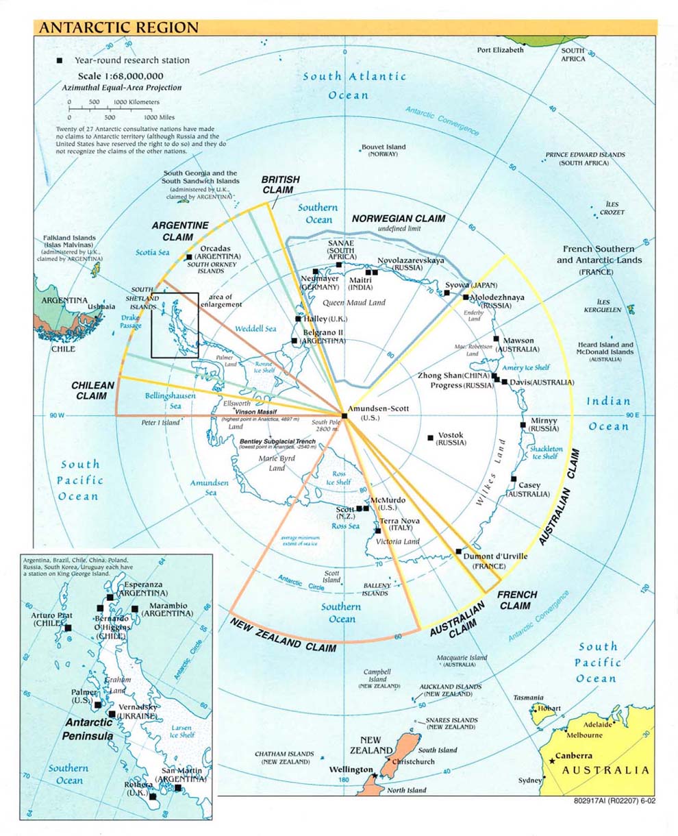
http://www.lib.utexas.edu/maps/islands_oceans_poles/antarctic_region_pol02.jpg
& this extreme megapoint was until its discontinuance & would still have been today the undisputed global maxipoint
with no serious competition anywhere in sight

but in fact the very quest to recognize & reach the true & present global maxipoint has constituted a trypointing try in its own right
involving a multitude of factors

for if there had been in existence any worldclass megapoint at all
which is to say
any multicountry conjunction more complicated than an ordinary trijunction
it is unlikely that the global maxipoint quest would have progressed any farther than that point

as recently as the 1990s boundary scholars could not rule out the possibility of a quadricountry point existing at the terrritorial convergence of botswana namibia zambia & zimbabwe
in the confluence of the chobe & zambezi rivers
not far above victoria falls

& this was the great bwnazmzw hopeful
so called
holding out against all probability in face of both poor mapping & international disputes
until satpic images revealed it was really not a quadripoint at all
but rather a distinct bwnazm tripoint & a distinct bwzmzw tripoint
both afloat within the river confluence area all right
yet still about 350 meters apart

so this leading candidate to succeed the south pole as global maxipoint has bitten the dust
& has had to be content of late as just a very distinguished & very close couple of members
of the worldclass set of 176 coequal tricountry conjunctions

& with the primary level of multipoints thus positively confirmed to comprise only tripoints & to be in fact devoid of any megapoints
the quest for global maxipoint then necessarily fell back upon the megapoints of the secondary level

& here there is no great scarcity
for subdivisional quadripoints like the famous azconmut or indian 4corners of the southwestern united states are confirmed or very probable in quite a few countries
such as andorra argentina bulgaria canada the dominican republic gabon india jamaica liechtenstein libya mauritania oman the philippines st kitts & nevis sudan uganda vietnam etc

indeed a subdivisional quadripoint & even a quintipoint exist among the parishes of st kitts & nevis respectively as numbered below at 2 6 9 13 & 4 5 7 10 12
tho these were only recently revived politically after languishing in obscurity for a time as purely ecclesiastical relics
Parishes of Saint Kitts and Nevis


&
for lack of any clear predominance within the primary level
owing to the general numerical similarity of all the 176 worldclass multiconjunctions
& for lack also of any clear predominance among the many second order quadripoints in the world
the recently revived nevis quintipoint
being technically the grandest second level multipoint in the world
may serve today by default as the most eminently complicated of the major multipoints
& thus as a sort of global maxipoint
tho not a very good exemplar really
since a secondary quintipoint represents neither the highest available political level nor the highest available numerical level
but would be at best a result & expression of compromise & inexact thinking
& thus not a very successful outcome of an earnest & multipunctilious trypointing try

moreover it may well be fairer to say that the florida quinticounty point in lake okeechobee
tho technically of only the tertiary level
is geopolitically far more important than the secondary level quintipoint of st kitts nevis
in terms of its constituent population data & the actual political clout of the entities involved
inasmuch as the least of the 5 okeechobee counties is more populous than the entire island of nevis
& the full population of all the 5 okeechobee counties is 135 times greater than all nevis
while a comparison of the total geographical areas covered is more overwhelming still

but in any case
in the belief that the okeechobee quintipoint was the global maxipoint at the time
a demarcation expedition was undertaken in 2001
from which the following pix are outtakes
http://tinyurl.com/6p7eho
http://tinyurl.com/6zzmsy
http://atsmedia.cachefly.net/uploads/ats33593_lake.jpg

an account of the try is given here
http://groups.yahoo.com/group/BoundaryPoint/message/1391

but all this was actually a bit naive

for upon further revelation & reflection as well as the passage of time
it now seems the maxipoint quest has no choice but to settle exclusively upon the greatest known number of component entities
& to disregard their political levels entirely
since the seemingly objective subdivisional ordering of primary secondary tertiary etc is as often a matter of local idiosyncrasy or happenchance as it is a reasonable measure of comparability

so the question has become
& will remain til a worldclass quadripoint should emerge to trump it
where is the numerically greatest multipoint in the world
without regard to geopolitical level

&
tho a few more quintipoints were subsequently found on various levels
several years then passed by without any clear determination of what might trump what
in point of preeminence
before the staggering finnish octapoint was discovered
& a few more years until the no less staggering philippine octapoint also turned up to join it in a tie for first place
in company with a similarly unique tho slightly less remarkable philippine sexipoint
to claim third place all by itself
& simultaneously with these 2 clear medalists
a supporting crowd of equally unexpected philippine quintipoints too

& so for a while the 2 octapoints have reigned as dual or twin global maxipoints
since the question of supremacy couldnt reasonably be called in favor of either one

the best sources make them both out as quaternary level entities
& both are technically octamunicipal too
& their exact ages are still unknown
so they have made a fairly good pair until now

indeed it seems ironic if not an outright cosmic joke that the great quest for a single global maxipoint will have finally been fulfilled
not by a more effective search or try but simply by the ongoing process of political development

yet it feels quite appropriate & satisfying to find that the new global maxipoint designate is in such a dramatic situation atop the spectacularly beautiful & highly active mayon volcano
even as the mountain itself has been deservedly nominated to become one of the new 7 wonders of the world in the following entertaining presentation
http://tinyurl.com/6dkjgj

best known pic
...the summit....
from
http://www.panoramio.com/photo/3962170

& finally it is also gratifying to find that all the numerical classes 3 thru 8 of the multipoints
from the almost ubiquitous tripoints & the modest scattering of quadripoints to the preciously rare quintipoints & the individually unique sexipoint septipoint & octapoint inclusive
will soon be represented for the first time in every category by a real example or examples

Sunday, October 19, 2008

try for atczsk greatly improved at last

after many near misses from the banks of the morava & thaya for this wet tripoint at or near mid confluence
recently pinned & just found at google earth is this dramatic new photo
http://www.panoramio.com/photo/12055511Dreiländer CZ-SK-AT
clearly showing a much closer near miss than ever
by a party of canoeists

highest salutes to the unknown photographer bikerbm & the unknown canoeists alike

it is even quite possible that the party or some part of it actually reached the exact tripoint
whether deliberately or fortuitously
in the process

this point lies on the austro hungarian divide of 1867 & earlier

but it appears to date only from the treaty of saint germain in 1919
when czechoslovakia formally gained from austria the march thaya triangle
a small area on the left bank of the thaya that had previously belonged to upper austria rather than moravia

the predecessor tripoint within the austro hungarian empire had also been situated on the morava
but actually a few kilometers above the thaya

a 1928 agreement between austria & czechoslovakia fixed both of the present austrian components
atcz & atsk
at the median line between the river banks
of the thaya & morava respectively

the czsk component is therefore very likely also at the median line of the upper morava
whether definitely or only presumptively

Thursday, October 16, 2008

a brief history of czplsk

the czpl component of czplsk
appears to date from the spa conference of 1920
when teschen silesia was partitioned between czechoslovakia & poland
along the dashed line shown by this map
Polish map of Cieszyn Silesia. The solid black line is the historical border of the region, and the broken black line is the international border.
for enlargement & source please see
http://en.wikipedia.org/wiki/Image:Slask_cieszynski.png


& since this territorial allocation disregarded existing municipal boundaries within silesia
most notably those of the city of teschen itself
there is probably little point in seeking an antecedent subdivisional tripoint at present czplsk


the plsk component of czplsk also appears to have been settled by 1920
as this border change map also suggests
Map of Zaolzie with territorial changes
enlargement & source
http://en.wikipedia.org/wiki/Image:Zaolzie_mapa.jpg

indeed the alignment shown for the eventual plsk boundary may simply have followed the austro hungarian divide of 1867
which may itself have adhered to still earlier boundaries


but in any case
both the czpl & plsk components of 1920 were confirmed or reaffirmed in 1958
by czechoslovakia & poland


& the czsk component may well have existed in its present form since the beginning of czechoslovakia & poland in 1918
also following the austro hungarian divide of 1867 & its antecedents

but the czechoslovakian portion of silesia was in any case formally merged with moravia in 1928 into the moravskoslezske region depicted by these maps
Country Moravskoslezské administrative breakdown in the years 1928 - 1938

& this grouping was merged in turn with the bohemian region to form the czech socialist republic within czechoslovakia in 1948


so
all these data
when combined with the apparent fact that czplsk remained unmarked until 2007
do strongly suggest that the exact czplsk tripoint location is relatively young as a tripoint
& that its trifinial configuration was most likely completed in its present form by 1920

Tuesday, October 14, 2008

more about czplsk

tho the czplsk tripoint has been a tricountry point since the disintegration of czechoslovakia in 1993
& was monumented indirectly in 1995 by the 3 well known obeliskoids that have been profusely photographed & hung at google earth etc
the direct demarcation by a fourth & much smaller obeliskoid was not completed until 2007
& has so far gone largely unnoticed or overlooked

indeed outdated information such as the following can still be found on the internet
http://www.volny.cz/obec.hrcava/trojmezia.html
tho presumably the definitive distances given in it remain correct
now that the tripoint itself is also marked directly

this rather stunning & memorable first known photo of its new & only known true marker was lifted from the first known public report of it
which is also linked below

http://fotoforum.gazeta.pl/3,0,723115,2,6.html

based on the recently revised official czech depiction of
the czech border at
http://tinyurl.com/35697q
& based also on an earlier indication
by
eye witness
jesper nielsen
which is hopefully still shown
at the bottom of the following page
http://tinyurl.com/3gvqho
if not also here below

showing in red the presumed locations
of the 3 older obeliskoids
before the official czech border depiction was corrected

the following revised tripoint stretching diagram guess
using the czplsk border trijunction shown at google earth
is likely in order now


& this geoposition is indicated by google earth
at roughly nlat49d31m01s75 & elong18d51m04s87